 |
Ken Baldry crosses Switzerland on Foot -The grand Rhätikon alternative start |
 |
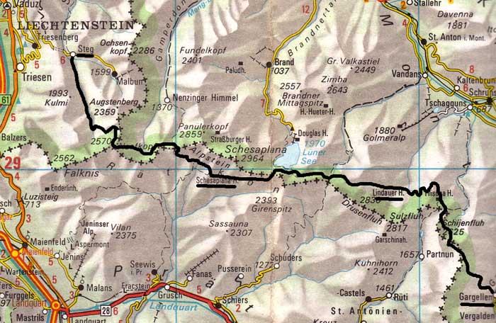 |
Alternative Start from Gargellen to Vaduz (Rhätikon trip)This is a great way to start the Cross-Swiss Walk, although for the first three days, one is in and out of both countries and Liechtenstein. This map is copied from the Official Map of the Automobil-Club der Schweiz, (with their permission) which is on this link but not to scale |
Saturday 23rd August - Walk in
I was away at 0555 to walk to Kings Cross & get the tube to LHR for the 0810 flight. Perfect timing. Got to ZUR at about 1050 & caught an express, first stop Landquart at 1147, where I changed for Klosters Dorf & arrived there at 1421. The Madrisa cable car is now a gondelbahn to 1887m, so no hanging about. It was a nice day & I had allowed 3 hours to walk over the Schlappinerjoch to Gargellen 1423m. It took longer than 1.5 hours to get to the joch at 2202m but less to walk down. I avoided Vergalden at the bottom & took better photos for my cross-Swiss book (& later, this web site). I checked into the Hotel Tilisuna, had a bath & the menu - pilz & pea soup & pig ghoulish, followed by a Coupe Danemark, which went down rather heavily. This was the best walk-in I can remember, as I seemed quite fit, despite much less training than usual. This may be because I was a stone lighter this year. I did get blisters, though.
Sunday 24th August 1997 Sarotla, Passagen, Gruben & Schwarze Scharte Passes, maps LK 248 and LK 238
Good buffet breakfast & only 340 sch! I was out at 0810 - just as well as I only got to the Lindauer Hütte at 1625 & it was a hotter day.
The initial slog up through steep wood paths & over fields was in shade, so I did not need my brolly up until I was on the long traverse from pt 1907 to the upper cwm below the Sarotla Pass 2389m. 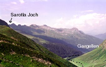
The Gargellertal |
Ken on the Sarotla Pass |
That had been improved by a pair of long zig-zags & I got to the top at 1145, the high point of the day at 2389m where I had lunch (dried fruit mixture) & finished my first bottle of water (I had bought another of the green plastic 1 litre ones, which slide into a rucksack more easily than the aluminium one). But there were three more passes. A simple traverse slightly down to the Passager Pass (2354m, this bit in Switzerland - one keeps crossing the frontier on this trip). Then back into Austria & a long valley down & up to the Gruben Pass at 2232m. The geology changes from schist to limestone & the flowers change, with a sudden eruption of Doronicons.The Gruben is not crossed (back into CH) but a side path goes to the Tilisuna Hut, where I had a mineral water. Then, up to the Schwartze Scharte, 2336m & over into the valley with the Lindauer Hut, 700 metres below & up a bit at 1686m. |
The superb view of the Rhätikon opens out here. The ridge down, the notorious Bilkengrat, has well laid out zig-zags, hundreds of them & rough. It was now very hot & my water ran out, so I staggered up through the woods to the hut at 1707m, dehydrated, which I fixed with 2.5 litres of expensive Apfelsaft, interspersed with Erbsensuppe & a superb Paprikaschnitzel, piled high with peppers & rice. I had been told the food was good in this hut. I talked to a Swiss guy from Basel going the other way. I went to bed at 1940 but it was quite noisy for a while. The huttenwirt was reluctant to sell me a room & said the lager was better. Balls. At least, I got some sleep in my cell. It was quite expensive altogether to stay here: 115sch for the cell, 311 for food & drink & another 90 for breakfast in the morning = 516sch (about 40 euros) altogether, compared to 550 yesterday. As a schilling is a shilling at the moment, this is still a cheap trip.
Monday 25th August 1997 Ofen Pass, Verajoch & Cavalljoch
Up at 6 for the minimal breakfast & out at 0648, the first I think. It took just over two hours to get up the long valley to the Ofen Pass at 2291m & it has two false summits but one feels, more or less correctly, that the back of a three pass day has been broken. A splendid view over to the Grosse Valkastiel between here & Brand. There is a 200m drop to the top of the Schwarztor, another pass into CH to ignore & a bit more up to the Verajoch at 2330m, the high point of the day, during which I saw a number of marmots, some of which did not think I had seen them. It is a long walk down to pt 2071, where I stopped for lunch.
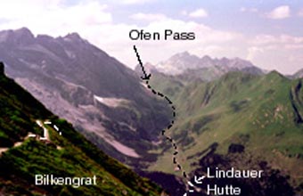
Ofen Pass from the Bilkengrat |
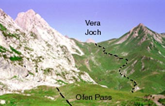
Vera Joch from the Ofen Pass |
There was a view down the Lunersee to the Douglas Hut (barracks). Like most dammed lakes, this is damned to a sinister feeling of mild horror & not in any way attractive. Then, a couple of hundred metres up mostly grassy cowed slopes to the Cavelljoch (2239m) & back into CH for the long & slightly improved (from my 1961 map) path to the Schesaplana Hütte (hut's website on this link) at 1903m. I thought this would never end but I was there by 1430, 7 hours, 40 minutes which was not bad. People in the Lindauer Hut thought I was going a long way. The Schesaplana Hütte is simple & very Swiss but it did do halb-pension. The dinner was a sort of Bersteigeressen of penne, cheese & minimal speck after a thin vegetable soup. I ate with some Germans, Peter (who spoke no English) with his son (13), then Olaf (from Ravensberg) & Reiner (from Friedrischafen, where they are making airships again) who did. There was a Swiss guy from Luzern as well. As I was in the lager (only about half a metre each & it was full), there was no point in going to bed before the rabble at 2130. The lager was in a separate hut & we had a storm with hail (hagel in Deutsch) during dinner. Fortunately, it stopped. I do not normally sleep well in lagers & didn't.
Just as well, as it was long - 8 hours, 20 minutes to Steg at 1303m. I had a cider in the hut but the path I intended to take was closed & I had to go down what was probably a better path to Vorder Säss, which picked up a jeep track & road a long way north to Steg. I was now going very slowly & did not understand until it dawned on me that I must be exhausted. Disaster - the only hotel in Steg closes on Tuesdays but I had effectively completed the Rhätikon from end to end, so I thumbed a lift & a girl gave me one through the tunnel into the Rheintal (which I did not really fancy walking anyway) & dropped me at the second hotel (her sister's?) in Triesenberg, Hotel Martha Buhler, only a shower but heaven anyway & a schweinschnitzel for dinner. Some day, I must go to Steeg & walk the whole way down.
|
Wednesday 27th August 1997 LK 237 Maybe I should have kept the lift longer but the walk down to Vaduz (Vadoots) was mainly through the woods & quite interesting. It went past the castle, which has been modified over the centuries, the last major addition being artillery bastions & only became the local Headman's residence a century ago after being a castle, prison, derelict etc. The population of Liechtenstein is only 29,000 & it is divided into 9 (!) boroughs. Like Luxembourg, this is the tatty end of the Holy Roman Empire. Vaduz, the 'capital city' is an undistinguished village but not all (or many) of the buildings are banks, as rumour has it. |
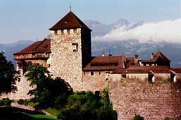
Vaduz Castle |
I walked out on a draggy suburban road towards Schaan to go to the Toggenburg. For the sake of completeness, maybe I should have walked to Sargans but feel this would be beyond the call of duty.
Contact: Ken Baldry, 17 Gerrard Road, Islington, London N1 8AY +44(0)20 7359 6294 or e-mail him
URL: http://www.art-science.com/Ken/Alpine/XSwiss/alpine11.html Last revised 23/5/2012 © 1998-2012 Ken Baldry. All rights reserved.