 |
Ken Baldry's Alpine PagesBella Tola (3025m) is the best viewpoint in the Swiss Alps - 1 |
Next page for the views & way down.
Also the next stage on the Chamonix-Zermatt walk
Bella Tola
|
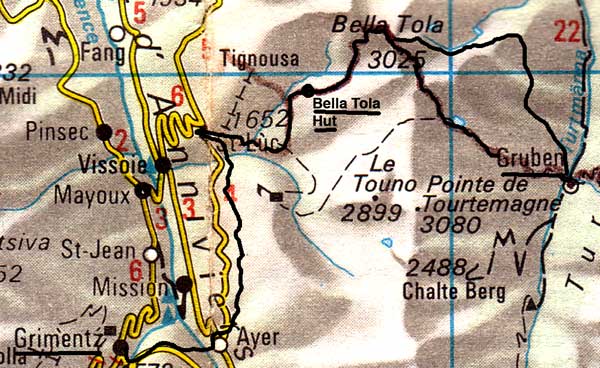
This peak, although of modest height, is the one peak you must do if you only ever do one, because it stands out in the Rhone Valley above Sierre in such a way as to give a splendid view of the Berner Oberland peaks but also a view of the Pennine Alps (the lot, including the Matterhorn) in such a way that the only important peak masked by another is Monte Rosa. It is a straightforward walk up from the East (the obvious side to start) & I have done it twice:- This map is copied from the Official Map of the Automobil-Club der Schweiz, (with their permission) which is on this link but not to scale |
 |
Route One - St. Luc
In July 1982, Dad & I were in Montana. Here is my diary entry:-
"We had to get over to St. Luc, high above the Val d'Annivers, today, so we walked down to Sierre. This was nicer than I had expected as it is all farming country after the holiday flats etc of Montana. We did see some curling in the ice rink there. Montana village which is some way below the Bournemouth stuff, is still a little farming village. The vines take over by the lower 1/3 & very industrial they are - lots of plumbing. We got to Sierre Station with seconds to spare for the bus. This takes you up a hairy road to Vissoire where buses from all directions met. St. Luc is tiny & just getting into skiing. We arrived for lunch on the balcony of the Pension La Fougère with a view of the Matterhorn, Pointe de Zinal, Obergabelhorn & Besso. I had not expected the Matterhorn here. There is a chairlift to the ski area, in 2002, it was a funicular, so we walked up to Tignousa, where it ends & tomorrow, we will use it, so we will have walked all the way up. We walked back a different way. The Pension has a reputation, justified, for food & we had my favourite Sole Bonne Femme."
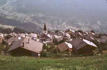
St. Luc in 1982 |
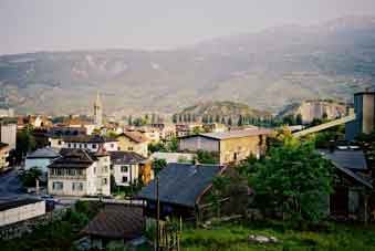
Chippis in the Rhone Valley, just as the path starts |
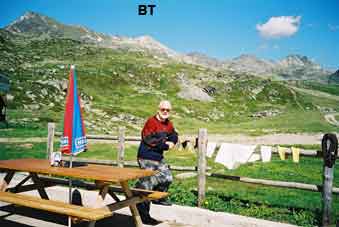
The author, his laundry & Bella Tola (BT) from the hut |
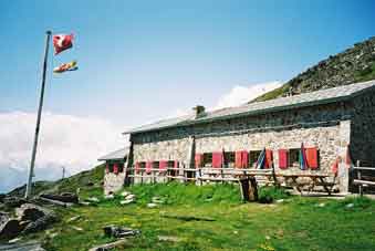
Cabane de Bella Tola |
Route Two - From Sierre in the Rhone Valley
Wednesday 26th June 2002
I snacked on two Nutrigrain bars & half a mint cake for my breakfast & left at 0635. I walked down to Chippis, crossed the Rhone & turned left into the Rue d'Annivers, a short road which has the 'up' starting immediately at its end. The path goes steeply through the woods, crossing the road a few times but peters out at an 'improved' bend, so one has to go up it for a while until houses below Niouc appear, where one can cut across the fields by the road to pick up the marked footpath up to Beauregard (where another footpath joins from the motorway junction East of Sierre). Then, it is stiffly up again but, where it crossed a logging road at Le Couquelle, it was diverted awkwardly to the West on a steep route (marked with police tape) which was not a path & very tiring. This rejoins the proper path later up the ridge clearly seen on the map & then traverses East to Ponchet & gradually bends South to Chandolin, to which I dropped thankfully for a large lunch of soup & boeuf bourguignon. Then, back up a bit to a traverse path to Tignousa (the higher one, not the one in the woods) & a short climb to the Cabane de Bella Tola. 9 hours altogether with a lunch hour & 1830 metres of up. This is a private hut (a converted ski hut) & had showers. I washed all my clothes, which rapidly dried in the sun & wind. My dinner was a käseschnitte. I had a long chat to the largely English-speaking Wirt (landlord) & was the only one in the dormitory.
Let's climb the hill...
Thursday 27th June 2002
I had a large breakfast at 0620. The bill was Sfr62 (including yesterday's beers) & I was away at 0645. The route follows the jeep track, then breaks clearly to the left (North) & rejoins it later, having avoided some down & up. Then, there were zig-zags to the ridge North of the top (3025m), where I arrived at 0900. This was very windy & rather cold, so unusually, I put on my anorak.
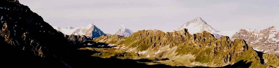
Obergabelhorn, Besso, Matterhorn & Dent Blanche on the way up
Next page for the views & way down.
Also the next stage on the Chamonix-Zermatt walk
Contact: Ken Baldry for more information, 17 Gerrard Road, Islington, London N1 8AY +44(0)20 7359 6294 or e-mail him
URL: http://www.art-science.com/Ken/Alpine/BellaTola/index.html © 2002-2008 Ken Baldry. All rights reserved. Last revised 26/6/2008