 |
Ken Baldry crosses Switzerland on Foot -The tougher alternative to the Klausen Pass - the Bärentritt & Chinzig Pass |
 |
|
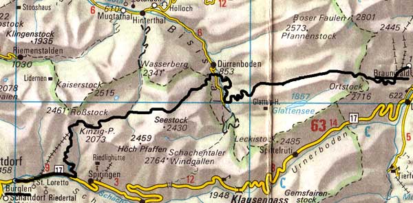
Alternative to the Klausen Pass - Braunwald to Brüsti for the Surenen Pass via Dürrenboden in the Bisistal & the Chinzig PassThis map is copied from the Official Map of the Automobil-Club der Schweiz, (with their permission) which is on this link but not to scale |
|
At the high point at Erigsmatt 2082m, there was a solid hut for the shepherds & I met a couple who were going to the Glattalp Hütte. They were 1/4 mile ahead of me for the next several miles across the desert & sheep pastures. A considerable stream disappeared into a sink-hole, of which there were many. Near the Charetalphüttli (actually, a decent farmhouse), I saw the couple give up their Glattalp excursion, cross a huge pasture & resume my path. I was chased by cows but kept them at bay and eventually caught the kids up. By that time, he was worried that we had passed the path & my compass was ambiguous, so we wasted half an hour looking sideways until we a) found the cliff-top & b) saw the huts of the Mälchberg on the right path across a chasm. |
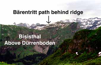 |
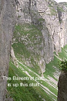
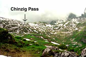
We went back up there & he asked a peasant who seemed amused when we said we were going down to Feldmoos (the top farm in the Bisisthal). This was one of the worst actual paths I have ever encountered, as it was steep, muddy & had blocks of greased limestone requiring the utmost care, dropping the 500m to Feldmoos. This goes down to the right of the prominent knoll in the photo above. Then, a long road walk, losing another 500m but with a couple of cut-offs. I staggered into the Schwarzenbach Guest House (955m) & they went on to the Dürrenboden bus stop. He was Swiss. She was French & totally done-in by the walk although they had taken the chair-lift to avoid the Bärentritt itself, the delights of which I listed for them. He was in computer development, so we traded notes. She ran kid's homes. They were astonished I had done the previous passes with a brolly up. They had done the Foo, then the Richetli yesterday but got the train to Braunwald, which is how they caught me up. It had taken me 9 1/2 hours to do what I had assumed incorrectly, would not be a too-demanding walk. I had a room with a shower for 40fr, dirt cheap & a good dinner of salad & Schweines Geschnectles & rösti.
|
There was some down to do & a path (marked on the map) went off south to save some height loss.However, when I got to the marked cowshed, it seemed to disappear, as it was much further down than I expected, so I moved across the hillside above where it must be, even though this was slow, expecting correctly to come across it eventually, which I did at Bödmer, not far below the pass. There was still much snow & it was quite hard work to the top. Some way down the other side, my watch dried out & worked again, suggesting that it had taken me 6.5 hours to get up, much more than I expected. At the top of a ski lift (Biel) I stopped for a beer. As well, as the going down seemed interminable, being further down than up. It seems inconceivable that Suvorov took his army over here in 1799 but it is clearly marked as the Suvorov Weg. After reaching the road, I walked along it to Bürglen, stopping at the first hotel there, the Waldhof. It had taken 10hr 20mins to do the walk. I flopped onto the floor for a bit before doing my washing & showering. Dinner was a real Cordon Bleu & actually cheaper than yesterday. Although the room was Sfr50, dinner was only Sfr20.60. My room stank of the cow shit they had sprayed on an adjacent field. There was a lot of rain & cow bells in the night. They must have been taking the cows up to the Summer pasture. |
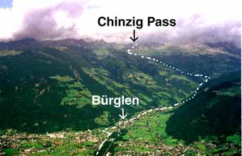
The view back to the Chinzig Pass from Brüsti In 2006: From the top of the Chinzig Pass, one can bear left down to Spiringen, a village on the original route and on the Klausen Pass road. This link suggests this is not a good idea. |
Thursday 15th June 2000 From Bürglen to Brüsti (half day)
|
Much to my surprise, there was a retired English couple at breakfast, Spain resident (I had noticed the Spanish plates in the car park yesterday). He was a bit blank (played a lot of golf) but she was very nice & once worked in Altdorf. I set off at 0930 & it took 40 minutes to get to Attinghausen, going along the other side of the stream from the arms factory. It was warm & took me 3.5 hours to get up the packhorse track to Brüsti. Some of it was muddy & slippery but most of it was still in good condition. Herr & Frau Eggman, of the inn by the top cable car station, are sweet & pretty old. There are no showers at all but I sort of washed. When I went out to look, there did seem to be rather a lot of snow up by the pass. A Californian family arrived at one point by the tiny cable car, then left. Dinner was a mixed salad, then fleischkäse with rösti & two fried eggs. This was much too early to attempt the Surenen Pass, as I found to my cost the next day, not having my crampons (!) However, this very hard pass is best crossed with an overnight stay at Brüsti. If you follow my original route over the Klausen Pass, it is no big deal to walk from Unterschächen to Brüsti in around 5 hours. |
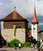
Bürglen's Wilhelm Tell Museum. Whether he was history or phony is not for me to say. |
An alternative to the Surenen Pass via Brüsti is the Susten Pass via Wassen
Contact: Ken Baldry, 17 Gerrard Road, Islington, London N1 8AY +44(0)20 7359 6294 or e-mail him
URL: http://www.art-science.com/Ken/Alpine/XSwiss/alpine10.html Last revised 26/6/2008 © 1998-2008 Ken Baldry. All rights reserved.