 |
Ken Baldry crosses Switzerland on Foot -Laret to the Heidelberger Hut |
 |
|
Next North East page: |
Laret to the Heidelberger Hut by the Zablesjoch & Fuorcla da Val Gronda
|
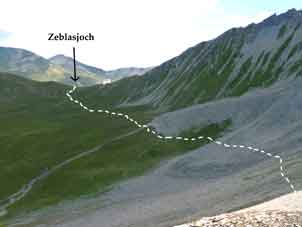
Wednesday 2nd September 2009 Rain was forecast but, although clouds came & went, no rain appeared. Good. The bill was sfr 98.50 altogether, about £60 & not bad. My debit card worked here which it did not in Landeck. A better cold buffet with fruit & yoghurt. It took a whole hour to walk up to Samnaun & then, a warm walk up the valley towards the Zeblasjoch. I met a couple of German ladies who were using the town picture map & were in entirely the wrong valley! I sent them on their way. It was quite a long way up the valley (not like yesterday, though) before zig-zags which were obviously, a ski run, appeared. Just above these, I met a group from Dresden & we chattered. There was a little house chalet in the meadows at the top with a little water mill for, presumably, electricity. Near the top, the Zeblas Joch (called, unaccountably, the Samnauner Joch on the map above) is off the jeep track, which goes on in the direction of the Paulinerkopf, so this is another way down from the ischgl ski area to Samnaun. |
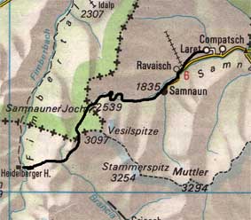
Map (not to scale) from the Official Map of the Automobil-Club der Schweiz, (with their permission) which is on this link. |
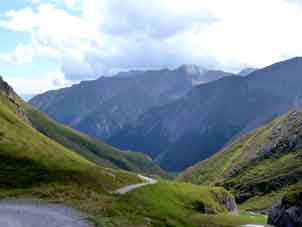
The ski run on the way up to the Zeblasjoch |
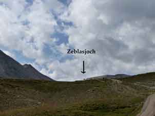
The Zeblasjoch from the Swiss side, just off the jeep track |
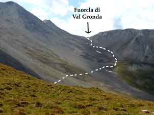
From the Zeblasjoch to the Fuorcla |
From the bottom of the Fuorcla di Val Gronda |
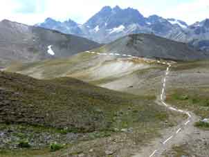
Towards the Heidelberger Hut from the |
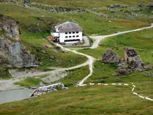
Heidelberger Hutte |
One loses about 100m from the pass to a traverse across a big stone field under the Vesilspitze to the start of the way up to the Fuorcla da Val Gronda, which is a fairly gentle climb up a slag heap but which does have a lot of flowers in it if you look. I photoed some. On the pass, you go back into Switzerland.
The path down to the Heidelberger Hutte (hut link) is longer than it looks on the map but one can see why the frontier does not seem to make sense on the map. looking down to the left (South-East), the scribble of valleys coming up from the Lower Engadine makes it impossible for it to go anywhere else. When the hut comes into sight, there is some steep & dirty path like something from the Lake District & 'receding hut syndrome' sets in. (The hut seems to retreat as you move towards it). it took me 6 hours 40 minutes to get there from Laret, about right. Compared to Swiss Alpine Club huts, the Heidelberger Hut is certainly posh. I took a room, half-board €40 (as an SAC member, although this is the only DAV hut in Switzerland, presumably because it can only be serviced from Austria). There was actual hot water in my room. I did my laundry & had an old-fashioned wash, then chatted to some Germans from Stuttgart, which is only 3 hours drive away. Over dinner, I chatted with a Berlin Zookeeper on my table & a Swiss couple resident in Marseilles who spoke English. Dinner was splendid: soup; tagliatelle with a mixture of meats & veg & a pud. €9.10 for beers & coffee. 26,890 paces.
|
Next North East page: |
Contact: Ken Baldry, 17 Gerrard Road, Islington, London N1 8AY +44(0)20 7359 6294 or e-mail him
URL: http://www.art-science.com/Ken/Alpine/XSwiss/alpine21.html Last revised 13/7/2011 © 2011 Ken Baldry. All rights reserved.